Contents
Overview
The mapping of Mars into standardized quadrangles, including the Syrtis Major region, is a direct descendant of terrestrial geological mapping practices, formalized by the United States Geological Survey's Astrogeology Research Program. This systematic approach to charting planetary surfaces began in earnest during the Space Race era, aiming to create a consistent cartographic framework for understanding extraterrestrial bodies. Early telescopic observations by astronomers like Christiaan Huygens in the 17th century hinted at surface features on Mars, but it wasn't until the advent of robotic exploration and orbital mapping that regions like Syrtis Major could be precisely delineated and studied. Refined data from missions like Mars Global Surveyor and Mars Reconnaissance Orbiter provided the detailed topographic and geological maps that define these quadrangles.
⚙️ How It Works
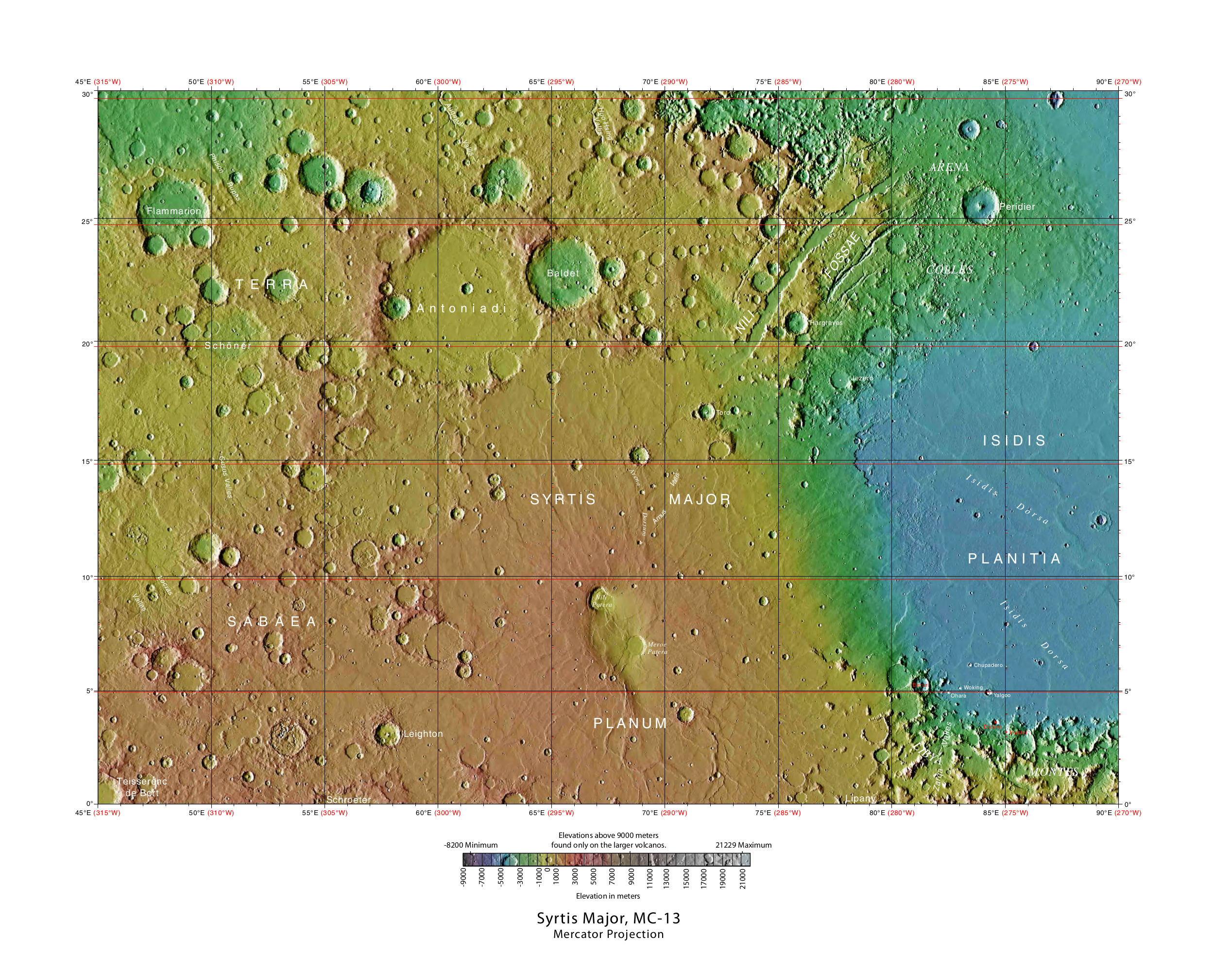
The Syrtis Major quadrangle is geologically diverse, featuring the eponymous Syrtis Major, a vast, ancient shield volcano. Surrounding the volcano are extensive plains, including parts of the massive Isidis Planitia impact basin to the east and the older, rugged highlands of Terra Sabaea to the south. The quadrangle's geology is further marked by features such as widespread dike swarms, which represent ancient volcanic plumbing systems, and inverted terrain, where erosional processes have sculpted ancient lava flows or sediments into ridge-like structures that mimic the original topography. These geological elements are meticulously mapped and analyzed using data from high-resolution orbital imagery and altimetry, such as that provided by the Mars Orbiter Laser Altimeter (MOLA) instrument.
📊 Key Facts & Numbers
The Syrtis Major quadrangle covers an area roughly equivalent to the size of the European Union. Within this expanse, the Isidis Planitia basin, which forms part of the quadrangle's eastern boundary, is one of the largest impact structures on Mars. The Beagle 2 lander was targeted for a landing site within the eastern Isidis Planitia, highlighting the scientific interest in this specific Martian locale.
👥 Key People & Organizations
The creation and refinement of Martian quadrangle maps is a collaborative effort primarily driven by the United States Geological Survey's Astrogeology Science Center. Key figures in planetary cartography and geology have contributed to the methodologies and data interpretation that underpin these maps. The Beagle 2 mission, a British-led effort, involved scientists from institutions like the Open University and the University of Leicester. The confirmation of Beagle 2's landing site in 2015 was a significant achievement by the NASA Mars Exploration Program, involving analysis of high-resolution images from the Mars Reconnaissance Orbiter.
🌍 Cultural Impact & Influence
The Syrtis Major quadrangle, as a cartographic product, has had a profound influence on how we understand Mars. It provides a standardized reference frame for scientific research, enabling geologists and planetary scientists to precisely locate and discuss features, compare observations from different missions, and build a cohesive geological history of the planet. The detailed mapping of Syrtis Major Planum, an ancient volcanic region, has been crucial for understanding Martian volcanism and its evolution over billions of years. The presence of Isidis Planitia within the quadrangle also draws attention to the planet's impact history. Furthermore, the area's association with the Beagle 2 mission has cemented its place in the public consciousness as a site of both scientific ambition and poignant loss.
⚡ Current State & Latest Developments
Current research within the Syrtis Major quadrangle continues to leverage high-resolution data from orbiters like the Mars Reconnaissance Orbiter (MRO) and ESA's Mars Express. Scientists are actively investigating the detailed stratigraphy of the Syrtis Major volcano, seeking to understand its eruption history and the processes that shaped its surface. Analysis of inverted terrain features is ongoing, providing insights into past fluvial or lacustrine environments that have since been eroded. The confirmation of the Beagle 2 lander's location in 2015 has spurred renewed interest in the eastern Isidis Planitia, with potential implications for future landing site selection and the search for evidence of past habitability. Ongoing spectral analysis of surface materials aims to identify mineralogical compositions, further refining our understanding of the region's geological evolution.
🤔 Controversies & Debates
One of the primary controversies surrounding the Syrtis Major region relates to the Beagle 2 mission. While its final resting place was confirmed in 2015, the exact cause of its failure to communicate after landing remains a subject of debate, with theories ranging from landing system malfunctions to antenna deployment issues. Another area of ongoing scientific discussion pertains to the precise age and formation mechanisms of the Syrtis Major volcano itself. Furthermore, the interpretation of certain geological features, such as the extent and nature of past water activity in areas like Isidis Planitia, can be subject to differing scientific viewpoints.
🔮 Future Outlook & Predictions
The future study of the Syrtis Major quadrangle will undoubtedly benefit from upcoming missions and advancements in remote sensing technology. Future orbiters may provide even higher resolution imagery and more sophisticated spectral analysis capabilities, allowing for a more granular understanding of the region's mineralogy and stratigraphy. The potential for future lander or rover missions to explore specific geological sites remains high, particularly given the scientific interest in its volcanic history and the potential for preserved evidence of past water. As our understanding of Martian geological processes deepens, comparative planetology will likely draw more attention to Syrtis Major as a key analog for understanding terrestrial volcanic and impact basin evolution.
Key Facts
- Category
- science
- Type
- topic